


final aéroport Mad

jmheydorff
User
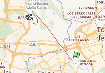

Length
8.2 km

Max alt
614 m

Uphill gradient
125 m
Km-Effort
9.7 km

Min alt
556 m

Downhill gradient
71 m
Boucle
No
Creation date :
2021-10-13 14:09:06.803
Updated on :
2021-10-13 14:30:07.072
8m
Difficulty : Very easy

FREE GPS app for hiking
 SityTrail
IGN / Geographical institutes
SityTrail Plus
The world is yours!
About
Trail Plane of 8.2 km to be discovered at Community of Madrid, Unknown, San Fernando de Henares. This trail is proposed by jmheydorff.
Positioning
Country:
Spain
Region :
Community of Madrid
Department/Province :
Unknown
Municipality :
San Fernando de Henares
Location:
Unknown
Start:(Dec)
Start:(UTM)
455602 ; 4476063 (30T) N.
Comments